Water: The Other US-Mexico Border Crisis That Is Growing Worse February 7th, 2025
Via The Conversation, a report on growing water tensions between the U.S. and Mexico:
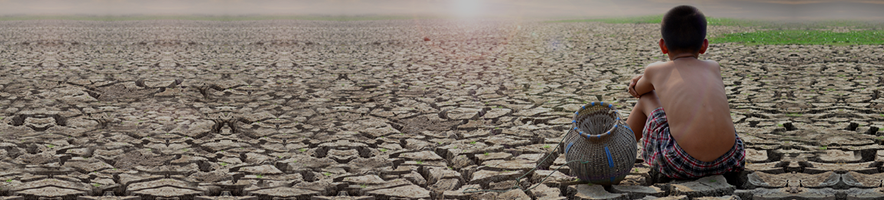
Immigration and border security will be the likely focus of U.S.-Mexico relations under the new Trump administration. But there also is a growing water crisis along the U.S.–Mexico border that affects tens of millions of people on both sides, and it can only be managed if the two governments work together.
Growing water use is already overtaxing limited supplies from nearly all of the region’s cross-border rivers, streams and aquifers. Many of these sources are contaminated with agricultural pollutants, untreated waste and other substances, further reducing the usability of available water.
As Texas-based scholars who study the legal and scientific aspects of water policy, we know that communities, farms and businesses in both countries rely on these scarce water supplies. In our view, water conditions on the border have changed so much that the current legal framework for managing them is inadequate.
Unless both nations recognize this fact, we believe that water problems in the region are likely to worsen, and supplies may never recover to levels seen as recently as the 1950s. Although the U.S. and Mexico have moved to address these concerns by updating the 1944 water treaty, these steps are not long-term solutions.
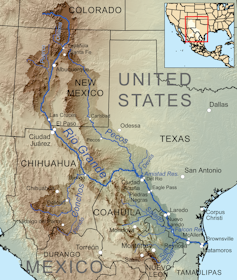
The Rio Grande flows south from Colorado and forms the 1,250-mile (2,000-kilometer) Texas-Mexico border.Kmusser/Wikimedia, CC BY-SA
Growing demand, shrinking supply
The U.S.-Mexico border region is mostly arid, with water coming from a few rivers and an unknown amount of groundwater. The main rivers that cross the border are the Colorado and the Rio Grande – two of the most water-stressed systems in the world.
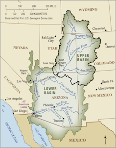
The Colorado River provides water to more than 44 million people, including seven U.S. and two Mexican states, 29 Indian tribes and 5.5 million acres of farmland. Only about 10% of its total flow reaches Mexico. The river once emptied into the Gulf of California, but now so much water is withdrawn along its course that since the 1960s it typically peters out in the desert.
The Rio Grande supplies water to roughly 15 million people, including 22 Indian tribes, three U.S. and four Mexican states and 2.8 million irrigated acres. It forms the 1,250-mile (2,000-kilometer) Texas-Mexico border, winding from El Paso in the west to the Gulf of Mexico in the east.
Other rivers that cross the border include the Tijuana, San Pedro, Santa Cruz, New and Gila. These are all significantly smaller and have less economic impact than the Colorado and the Rio Grande.
At least 28 aquifers – underground rock formations that contain water – also traverse the border. With a few exceptions, very little information on these shared resources exists. One thing that is known is that many of them are severely overtapped and contaminated.
Nonetheless, reliance on aquifers is growing as surface water supplies dwindle. Some 80% of groundwater used in the border region goes to agriculture. The rest is used by farmers and industries, such as automotive and appliance manufacturers.
Over 10 million people in 30 cities and communities throughout the border region rely on groundwater for domestic use. Many communities, including Ciudad Juarez; the sister cities of Nogales in both Arizona and Sonora; and the sister cities of Columbus in New Mexico and Puerto Palomas in Chihuahua, get all or most of their fresh water from these aquifers.
Precipitation patterns across the region are projected to be uncertain and erratic for the foreseeable future. This trend will fuel more extreme weather events, such as droughts and floods, which could cause widespread harm to crops, industrial activity, human health and the environment.
Under the 1906 treaty, the U.S. is obligated to deliver 60,000 acre-feet of water to Mexico where the Rio Grande reaches the border. This target may be reduced during droughts, which have occurred frequently in recent decades. An acre-foot is enough water to flood an acre of land 1 foot deep – about 325,000 gallons (1.2 million liters).
Allocations under the 1944 treaty are more complicated. The U.S. is required to deliver 1.5 million acre-feet of Colorado River water to Mexico at the border – but as with the 1906 treaty, reductions are allowed in cases of extraordinary drought.
Until the mid-2010s, the U.S. met its full obligation each year. Since then, however, regional drought and climate change have severely reduced the Colorado River’s flow, requiring substantial allocation reductions for both the U.S. and Mexico.
This agreement provides each nation with designated fractions of flows from the Lower Rio Grande and specific tributaries. Regardless of water availability or climatic conditions, Mexico also is required to deliver to the U.S. a minimum of 1,750,000 acre-feet of water from six named tributaries, averaged over five-year cycles. If Mexico falls short in one cycle, it can make up the deficit in the next five-year cycle, but cannot delay repayment further.
Since the 1990s, extraordinary droughts have caused Mexico to miss its delivery obligations three times. Although Mexico repaid its water debts in subsequent cycles, these shortfalls raised diplomatic tensions that led to last-minute negotiations and large-scale water transfers from Mexico to the U.S.
Mexican farmers in Lower Rio Grande irrigation districts who had to shoulder these cuts felt betrayed. In 2020, they protested, confronting federal soldiers and temporarily seizing control of a dam.
U.S. President Donald Trump and Mexican President Claudia Scheinbaum clearly appreciate the political and economic importance of the border region. But if water scarcity worsens, it could supplant other border priorities.
In our view, the best way to prevent this would be for the two countries to recognize that conditions are deteriorating and update the existing cross-border governance regime so that it reflects today’s new water realities.
This entry was posted on
Friday, February 7th, 2025 at
7:14 am and is filed under
Colorado River, Mexico, Rio Grande. You can follow any responses to this entry through the
RSS 2.0 feed.
Both comments and pings are currently closed.