BLOG
December 9th, 2019
Via Sustainable Waters, a report on the growing water crisis in the Colorado River Basin:

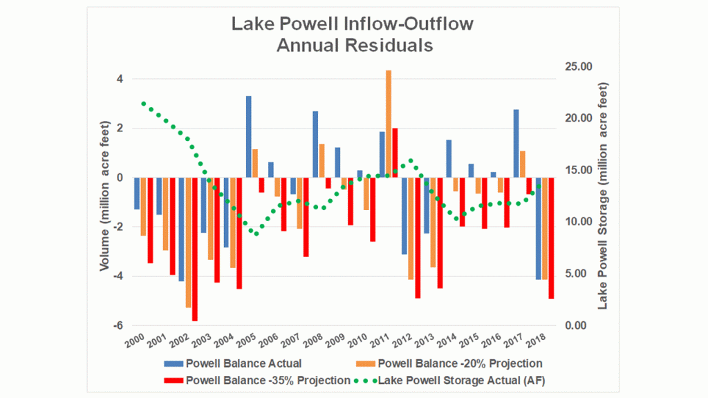
Image: Lake Powell lost nearly half of its storage capacity during 2000-2018.
It’s a bit hard to believe now, but back in 2012 there wasn’t a lot of talk about fresh water in the global dialogues on climate change. Yes, there was a lot of talk about sea-level rise, the impacts of warming temperatures on the livability of cities, the need to protect forests, and that sort of thing. But the concerns held by many freshwater scientists and water managers – such as fears of worsening freshwater scarcity in coming decades – were not getting any attention.
Anticipating further freshwater neglect at the upcoming 18th Convention of the Parties (COP) to be held in November 2012 in Doha, Qatar, the National Water Commission of Mexico (CONAGUA) hosted a preemptive water and climate conference in Mexico City to elevate freshwater concerns. I’ll never forget the words of CONAGUA’s director general in opening the conference:
“Climate change is the shark in our future and water is its teeth.”
There are few places in the world feeling the bite of those teeth more painfully than the Colorado River basin of the American West.
In recent blogs I’ve offered my thoughts and opinions about the growing threat of depleted river flows for highly endangered fish like the Colorado pikeminnow, the ways in which changes in land and water management in California can change rainfall in the Colorado River basin, and the opportunity to resolve water scarcity by paying farmers to reduce consumptive water use.
But during a recent interview, when asked how much reduction in consumptive use would be needed to stabilize the water level of Lake Powell, I was embarrassed to admit that I didn’t exactly know! In all the papers, reports, blogs and books I’ve read about the Colorado River, I have not come across a definitive answer to this simple question.
So I cooked up my own estimates. Or more precisely I’ve generated multiple answers, based on varying assumptions.
I created a simple water budget model, using estimates of reservoir inflows and evaporation from the US Bureau of Reclamation, and reservoir outflows measured by the US Geological Survey at Lee Ferry, Arizona, located just downstream of Lake Powell.
The results: Lake Powell lost nearly 600,000 acre-feet per year, on average, during 2000-2018.
That means that if you wanted to maintain stable reservoir levels over that time period, you would have needed to reduce consumptive use by that volume. Every year.
The longer we wait to begin aggressive demand management in the Upper Basin of the Colorado River, the further we’ll fall behind in the water budget, and the deeper the crisis we’ll be in. Further declines in Lake Powell’s water storage could lead to many frightening risks, including the possibility that trans-mountain water deliveries to Colorado’s Front Range cities (including Denver) could be substantially curtailed; that hydropower production at Lake Powell (Glen Canyon Dam) would drop precipitously; and eventually, the ability to release water from the reservoir to downstream states would no longer be physically possible when the reservoir level drops below release outlets.
Image: The balance of historical inflows and outflows at Lake Powell on the Colorado River from 2000-2018 reveals an average deficit of ~600,000 acre-feet per year.
The above statistics and the historical balances shown in the graph above (blue bars and green dots) are based on reservoir and river flow data from 2000-2018. It looks very bad, with half of those years showing big deficits, but it’s likely to get much worse. If you believe the climate forecasts by Brad Udall and Jonathan Overpeck (2017) – and I certainly do believe them – the rate of decline in Lake Powell storage levels can be expected to accelerate in coming decades, assuming future decades of water use resemble the past two, and existing requirements remain in place for releasing an average of 8.23 million acre-feet each year from Lake Powell as mandated by the Colorado River Compact.
Udall and Overpeck project declines in Colorado River flows of at least -20% by 2050 and -35% by 2100. Assuming the mid-century rate of declining flows, we should be reducing consumptive use by about 1.5 million acre feet each year. By century’s end, we’d need to be reducing consumptive use by 2.75 million acre-feet annually.
Some in the water management community and political leadership of the Upper Basin states still aren’t convinced that a demand management program to reduce consumptive water use is needed. I simply cannot understand why they would want to continue to risk potentially catastrophic disaster by waiting any longer.
As Anne Castle and John Fleck put it so poignantly in their recent assessment of water risks in the Upper Basin:
“Now is the time to think about our risks, and our insurance options.”
“Hope is not insurance.”
There are sharks in these waters. Treading water is no way to respond.