BLOG
April 1st, 2020
Via Sustainable Waters, rather sobering commentary and analysis of the grave future facing the Colorado River and its two main lake reservoirs:
America’s two largest reservoirs — Lake Mead and Lake Powell on the Colorado River — could both run of out water in just five years.
I really wish this was an April Fool’s joke. But instead, it’s a conclusion I came to after being asked by one of my University of Virginia students, “What would happen to those reservoirs if they had another bad string of really dry years?”
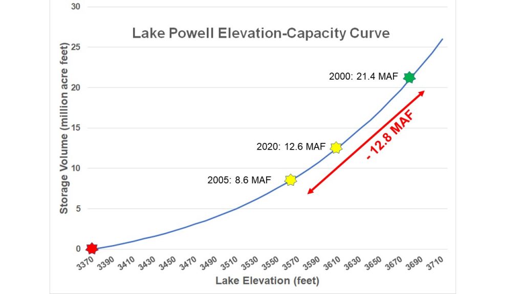
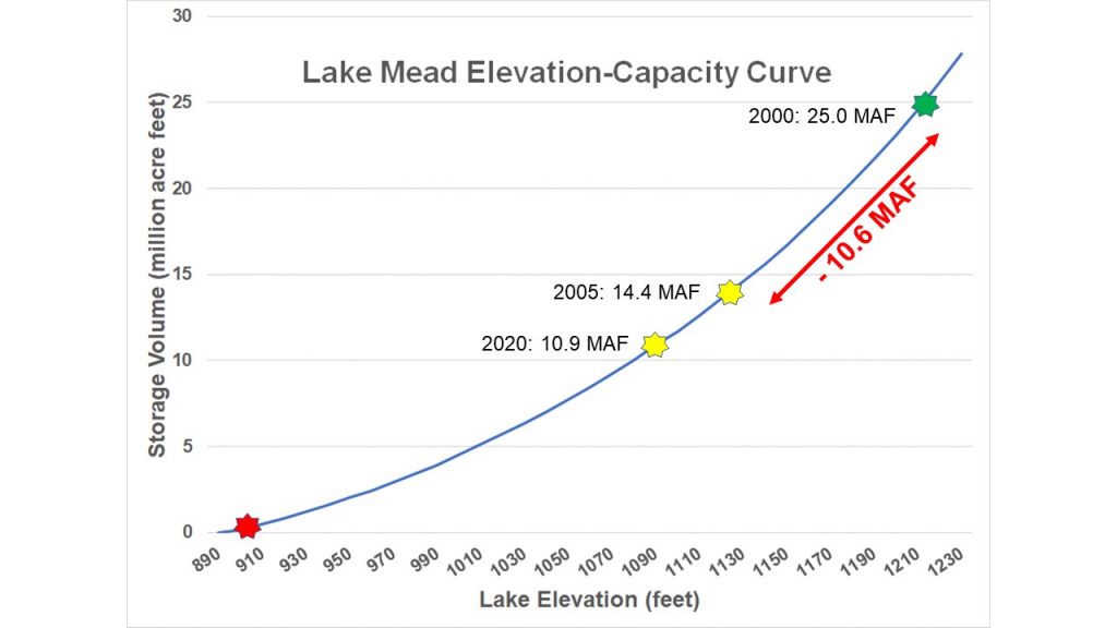
My distressing conclusion is based on simple math, as illustrated in the graphs below. On each graph, you can see how much water was stored in each of the two reservoirs on January 1st of 2000, 2005, and 2020. If you subtract the storage at the start of 2005 from the water stored in 2000, you can see how much water was lost during those five years (the answers are noted in red on each graph).
If you then take that same volume of water lost during 2000-2004 and subtract it from the current (2020) reservoir levels, you bottom out both reservoirs, as indicated by the red star in each graph.
The simple interpretation of these graphs is that if we were to have a repeat of the climate we had from 2000 through 2004, and if levels of water use remain nearly the same as they were in those five years, the two largest reservoirs in the United States would be out of water in five years.
Anticipating Your Questions
You might be thinking:
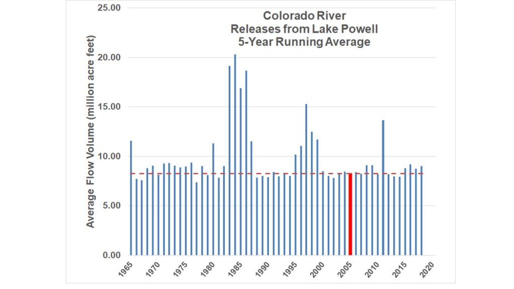
It’s highly unlikely that we’d ever have five years that bad again. In reality, we’ve had multiple episodes of similarly dry periods in the past century, as indicated in the graph below (yellow bars represent the end of 5-year periods similar to 2000-2004). And as climate scientists warn, we should expect more of these dry sequences in the Colorado River basin going forward because the climate is warming and causing greater evaporation. During the past ten years we’ve seen eight of the hottest years on record.
Lake Powell only dropped that much during 2000-2004 because the Bureau of Reclamation was releasing too much water to the downstream Lower Basin. In previous blogs, I’ve made the case that Lake Powell would be nearly full today (instead of half-empty) if the Bureau would have released only 8.23 million acre-feet per year — the average release required by the Colorado River Compact — over the recent decade. But during 2000-2004, the releases from Lake Powell averaged 8.2 MAF, the same volume that could be expected to be released during a future dry spell. The massive loss of water storage in Lake Powell during 2000-2004 can’t be attributed to excessive releases.
We’re not using as much water now as we did in 2000-2004 so the reservoirs wouldn’t drop as quickly. Not true for the Upper Basin states – they’re actually using a little more now. The Lower Basin states, on the other hand, have been doing a good job of reducing their water use, down about 10%, primarily because of great strides being made in urban water conservation. That helps reduce their risks, but it’s not enough to avoid serious shortages, as I’ll explain below.
The new rules put into place with Drought Contingency Plans would not allow the reservoirs to run out of water. If in fact the DCPs included full-fledged “demand management” (i.e., water conservation) plans, that would be true. But at present, the water-saving aspects of the DCPs is still conceptual, and lacking necessary definition, as I discuss below under “We’re Really Not Prepared for This”
The Potentially Damaging Consequences of Day Zero
I realize this is a horrible time to be talking about another potential disaster in our lives. But one thing that the global coronavirus pandemic is teaching us is that we’re going to need to learn to manage and adapt to multiple crises simultaneously going forward, e.g., viral infections and deaths, economic crashes, school closures, disruptions of commodity supply chains, political upheavals…… and water shortages. My mission at Sustainable Waters is to inform and educate on issues concerning water scarcity, and as I’ve been saying in the media and in these blogs, I think the water shortage risks on the Colorado River need a great deal more attention and immediate action. If the pandemic is teaching us anything, it’s the need to be better prepared, particularly for crises that can be reasonably anticipated.
I can hardly imagine what disastrous consequences Day Zero on the Colorado would bring. But here’s a starting list.
Lake Mead risks
- When Lake Mead drops below 900 feet, water can no longer flow out of the dam’s outlets. That means that thousands of water users in Arizona, California, and Nevada could be facing water shut offs or reductions. But Las Vegas will be OK for a while longer, because the city just built a massive new pipe into the lake — at a cost of more than $800 million — that can suck out water until the ‘dead pool’ of remaining water in the lake drops to 860 feet.
- Electricity cannot be generated at Lake Mead (Hoover Dam) when the reservoir drops below 950 feet, threatening to shut down electricity generation that could power 780,000 homes.
- The water shortage risks described above could happen in five years. Or they could happen much sooner, if Lake Powell — located upstream of Lake Mead — also drops to critical levels and can no longer release an average of 8.23 million acre-feet of water each year to meet the needs of downstream users.
Lake Powell risks
- Lake Powell (Glen Canyon Dam) will no longer be able to produce electricity when the reservoir drops below 3,490 feet.
- More calamitous is the fact that when water can no longer pass through the hydropower turbines, the dam can no longer release enough water to meet the terms of the Colorado River Compact that allocated the river’s water between the Upper Basin states of Colorado, Wyoming, Utah, and New Mexico, and the Lower Basin states of California, Arizona, and Nevada. When that happens, the Lower Basin states will surely howl and likely sue, triggering what is known as a “Compact Call.” The Upper Basin states are dreadfully fearful of a compact call because it means they will be forced to rapidly reduce (curtail) their use of the river. If the water shutoffs follow the existing legal order of water rights priorities, some of the first large users to get shut off would be the big cities like Denver and Aurora along Colorado’s Front Range.
We’re Really Not Prepared for This
I’ve offered my opinion of what I think needs to be done to stave off these catastrophic risks in previous blogs (e.g., pay farmers to temporarily fallow their farmland). And to give credit where it is due, there has been a great deal of conversation among the seven states sharing the Colorado River’s water, and they have reached agreement on some key elements of what a water-saving plan might include.
But to be very clear, no actionable plans exist that could adequately stave off disaster if it were to come at us as fast as the dry years of 2000-2004. Here’s where things stand at present, and what needs to be done immediately to responsibly manage our risks.
- In the Upper Basin, there is no agreed plan for how water would be saved, who would save the water, and how or even whether they would be financially compensated for doing so. A formal ‘demand management’ program needs to be set up in each of the Upper Basin states, willing participants need to be expressly identified, and the means for financially rewarding those participants needs to be clarified. Such a program would need to be capable of greatly, and swiftly, reducing water use. To maintain a stable Lake Powell during conditions like 2000-2004, water consumption in the Upper Basin would need to be reduced by 2.6 million acre feet per year (i.e., reduced to one-third of current water use), assuming that an average of 8.23 MAF/year would need to be released from the lake to help avert disaster in the Lower Basin. While it’s unimaginable that water savings that large are attainable, it points to the hard fact that Lake Powell would drop rapidly and we need to do everything possible to keep it from completely running out of water.
- In the Lower Basin, there is firm agreement in the Drought Continency Plan about how much water will be shut off to each state as Lake Mead falls to lower and lower levels. And there is a partial plan in place — in the form of ‘Intentionally Conserved Surplus’ agreements with various farming communities such as the Gila River Indian Community — to provide up to 625,000 acre feet per year of water savings. But there are two big shortcomings with the Lower Basin plans at present: (1) there is no identified source of money to reward those willing to save water beyond the first 150,000 acre feet per year; and (2) the total water savings committed in the ICS agreements (625,000 AF) is only one-half of what is needed (reduction of 1.2 million acre feet per year below recent usage levels) to keep Lake Mead stable during conditions like 2000-2004. The existing plan needs to be doubled in scope, and a source of funding needs to be identified to compensate farmers participating in the program.
The clock is ticking. The Bureau of Reclamation is now forecasting that river flows will be only 77% of normal this year. It’s clearly time for bold leadership and concerted action.


